November 21, 2024, 3:26 pm

Search Map

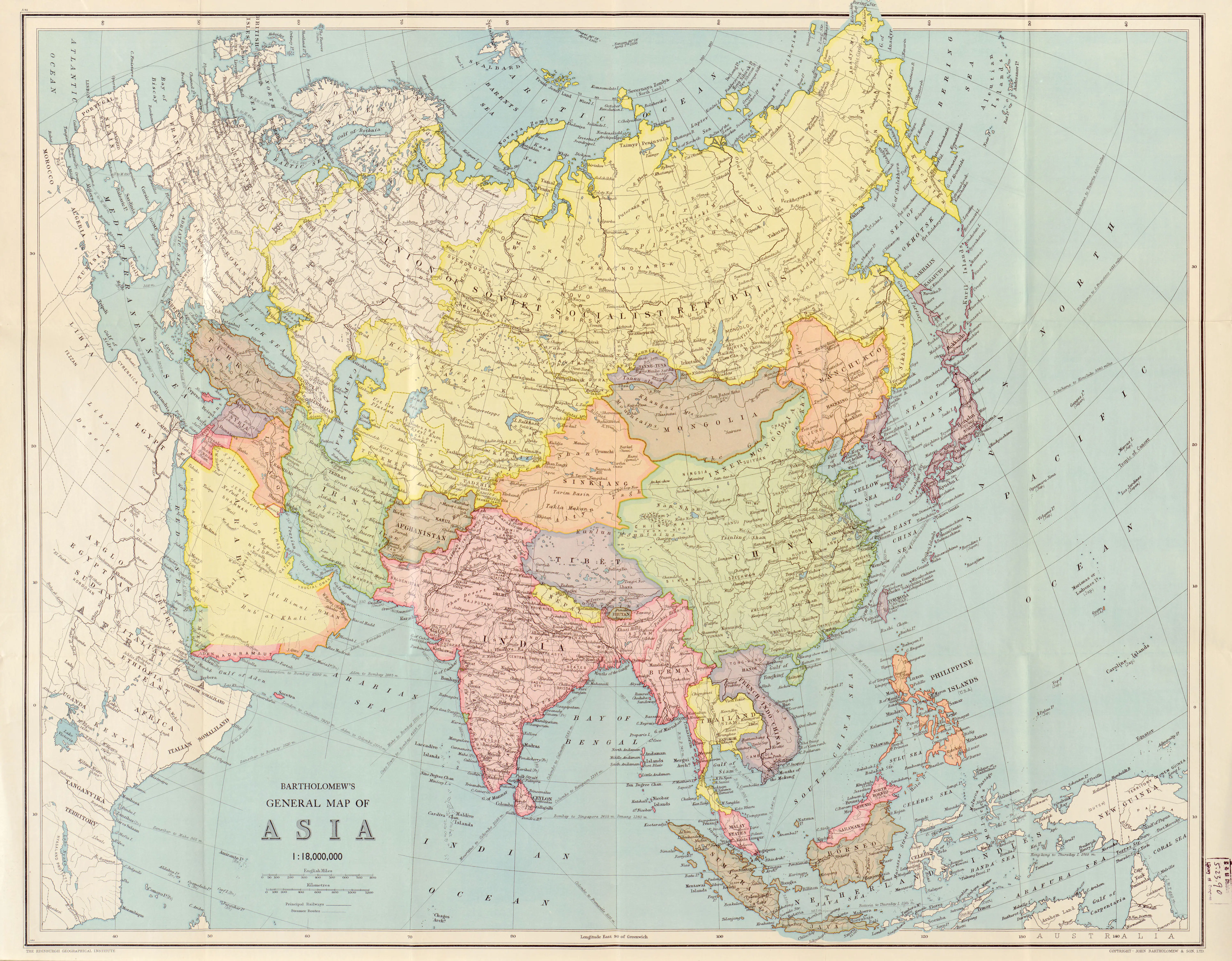
Bartholomews General Map of Asia.2, 1940


  • Bartholomews general map of Asia.2 - 1940
     
  • Bartholomew's General Map of Asia (1940) is a historical cartographic marvel that provides a comprehensive snapshot of the Asian continent during a pivotal period. Crafted against the backdrop of World War II, the map reflects the geopolitical intricacies and uncertainties of the time. Renowned for its meticulous detail, the map delineates the diverse nations, borders, and topographical features of Asia, encapsulating the geopolitical landscape of the mid-20th century.
     
  • Beyond its navigational utility, Bartholomew's map serves as a visual testament to the dynamic changes and geopolitical challenges faced by the region during 1940. As a valuable historical artifact, it offers a unique perspective on the political alliances, territorial shifts, and global dynamics that marked this critical juncture in history. The map stands as a testament to the cartographer's skill and the historical significance of the era, making it an invaluable resource for those seeking a deeper understanding of Asia's complex past

Map of Far East Australia, Indian Ocean Eastern Africa, India Asia, East Indies, And Australia

  • The Antique Map of Far East Australia: A Glimpse into Maritime Splendor and Cultural Riches


  • A captivating cartographic masterpiece, the Antique Map of Far East Australia unveils a panorama of the Indian Ocean and the enchanting coastlines of eastern Africa, India, Asia, the East Indies, and Australia. Richly adorned with intricate...


    View More

Discover Earth's Majesty: Ascending Order Geography Chart Featuring Major Mountains and Cities Across Continents

  • Nature's Grandeur Mapped: Ascending Order Geography Chart Reveals Majestic Mountains Across Continents
     
  • Embark on a visual odyssey through the "View of Nature in Ascending Order" geography chart by exploring the majesty of the world's continents and their towering peaks. This meticulously crafted chart showcases the major mountains in ascending order,...


    View More

Unveiling Beijing's Rich History: A Bilingual Journey to The Great Wall by The Beijing Chronicle in 1936

  • Bilingual Glimpse of Beijing and Beyond: The Beijing Chronicle's 1936 Expedition to the Great Wall


  • In 1936, the Beijing Chronicle unveiled a captivating bilingual perspective on the enchanting landscapes of Beijing and its surroundings, extending its gaze all the way to the iconic Great Wall of China. This rare and insightful...


    View More

Nueva GeografĂ­a Universal Map (1879): A Historical Cartographic Gem

  • Nueva Geografía Universal Map (1879):  A Historical Cartographic Gem & Details


  • The Nueva Geografía Universal Map of 1879 stands as a captivating relic of 19th-century cartography, offering a glimpse into the world as perceived during that era. Crafted with meticulous detail, this map is a testament to the dedication and precision of...


    View More

Historical Map of India And China 1750

  • Exploring 18th Century Asia: Historical Maps of India and China (1750)

  • Travel back to the 18th century with our detailed Historical Map of India and China from 1750. This map gives you a clear view of the past, showing political borders, cultural areas, and historical details of these ancient lands.
     
  • See...


    View More

Tropical Zone Wonders Unveiled: Yaggy's Geographical Posters Showcase Breathtaking Jungle Scenes and Wildlife

  • Exploring the Tropical Zone with Yaggy's Geographical Posters
     
  • Embark on a vivid journey into the heart of the Tropical Zone through Yaggy's geographical posters. The featured image unveils a mesmerizing jungle scene teeming with life and vibrant biodiversity. Exotic flora and fauna intertwine in a lush display, capturing the essence...


    View More
WhatsApp