September 8, 2024, 6:42 am

Search Map

Nostalgic Charm Unveiled: Explore the Fine Amos & Andy Promotional Map of Weber City with Original Letter and Envelope


  • Exploring Nostalgia: Amos & Andy's Mythical Weber City Revealed in a Vintage Promotional Map


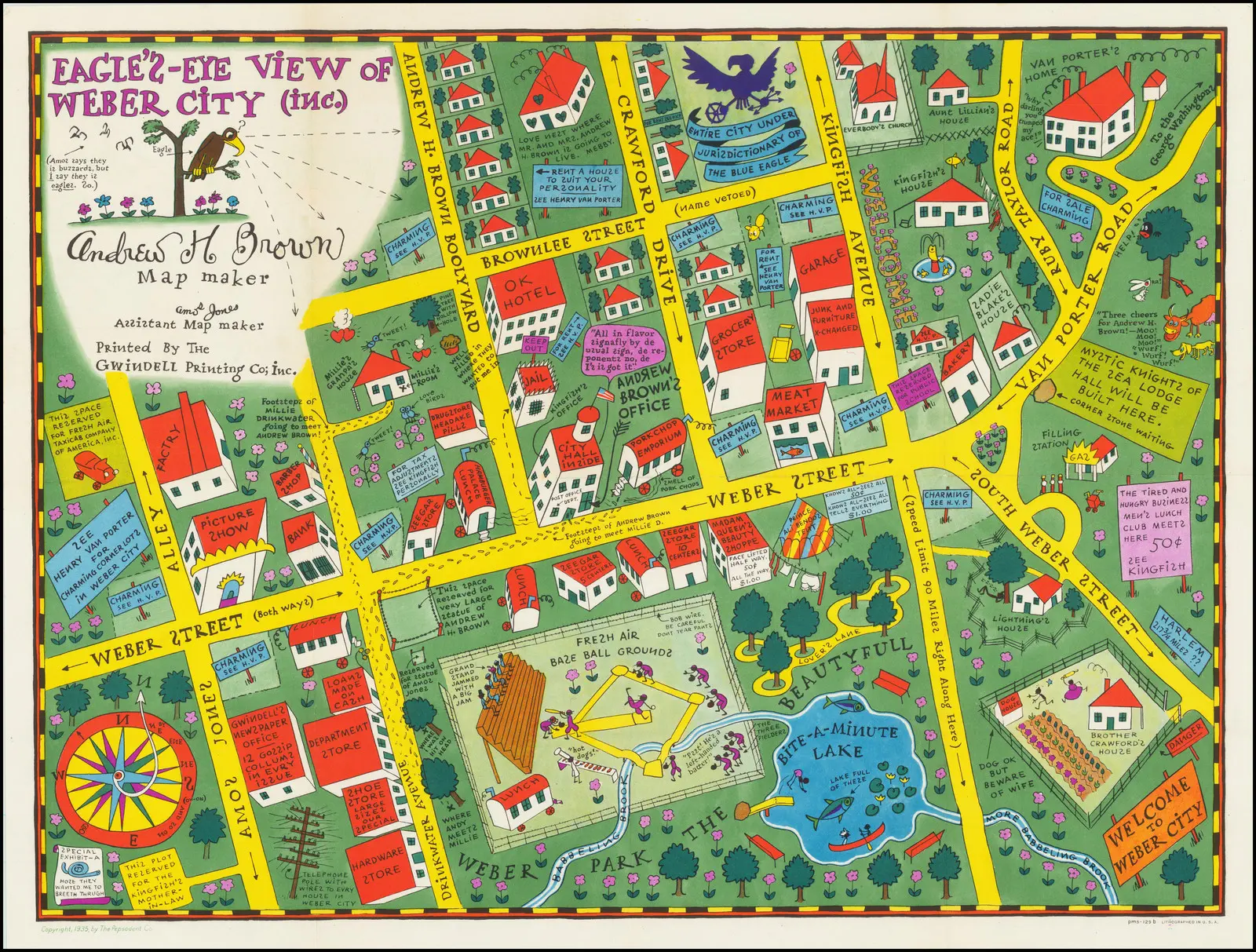
  • A fine example of cultural nostalgia comes to life through the Amos & Andy promotional map, showcasing their mythical town of Weber City. This vintage gem provides a charming glimpse into the fictional world created by the beloved radio duo. The intricately detailed map is a testament to the artistry and creativity that defined the era, capturing the essence of Weber City with its imaginary landmarks and whimsical charm.
     
  • Accompanied by a personal letter from Amos & Andy themselves, the map invites enthusiasts to step back in time and experience the humor and warmth that endeared the characters to audiences. Preserved within the original envelope, this piece of Americana not only serves as a tangible connection to the past but also as a fine example of the enduring appeal of Amos & Andy's cultural legacy.


Bartholomews General Map of Asia.2, 1940

  • Bartholomews general map of Asia.2 - 1940
     
  • Bartholomew's General Map of Asia (1940) is a historical cartographic marvel that provides a comprehensive snapshot of the Asian continent during a pivotal period. Crafted against the backdrop of World War II, the map reflects the geopolitical intricacies and uncertainties of the time....


    View More

1827 Map of Asia and Australia - Featuring Australia (New Holland) and East India Islands From the 19th Century

  • 1827 Map of Asia and Australia - Featuring Australia (New Holland)  from the 19th Century.


  • The Finley Map of Asia and Australia from 1827 is a remarkable cartographic representation that encapsulates the geographical knowledge of the time. In keeping with the conventions of 19th-century maps, this intricate depiction encompasses Australia, then referred...


    View More

Map of Asia: Explore the Near and Middle East, Russia, India, China, Japan, and More with Detailed Mapping of Korea and Japan

  • Exploring the Past: Old Map of Asia Unveils a Tapestry of Far-Reaching Lands


  • Dive into the intricate details of an antique treasure with our Old Map of Asia, a captivating cartographic journey that unfolds the landscapes of the Near and Middle East, Russia, India, China, Japan, Southeast Asia, the East Indies,...


    View More

Arctic Zone Exploration: Yaggy's Geography Print-Intriguing Illustration of Eskimoes, Kayaks, and Arctic Fauna in a Domestic Igloo Scene

  • Geography Print - Arctic Zone: Yaggy’s Captivating Illustration 
     
  • Geography Print - Arctic Zone" unveils an enthralling masterpiece by Yaggy, showcasing a vivid depiction of the polar wilderness. The poster transports viewers into the heart of the Arctic, where Yaggy's artistic prowess brings to life a domestic igloo scene. Immerse yourself...


    View More

Map of Far East Australia, Indian Ocean Eastern Africa, India Asia, East Indies, And Australia

  • The Antique Map of Far East Australia: A Glimpse into Maritime Splendor and Cultural Riches


  • A captivating cartographic masterpiece, the Antique Map of Far East Australia unveils a panorama of the Indian Ocean and the enchanting coastlines of eastern Africa, India, Asia, the East Indies, and Australia. Richly adorned with intricate...


    View More

Political Map of Asia 1934

  • Navigating the Past: Political Map of Asia (1934)
     
  • Step into the past with our exclusive Political Map of Asia from 1934, a vintage cartographic gem that provides a unique glimpse into the geopolitical landscape of the continent during a transformative period. Crafted with precision and historical accuracy, this map offers...


    View More
WhatsApp