September 8, 2024, 6:40 am

Search Map

Ronald Reagan's Global Impact: Unveiling the World Map Transformation


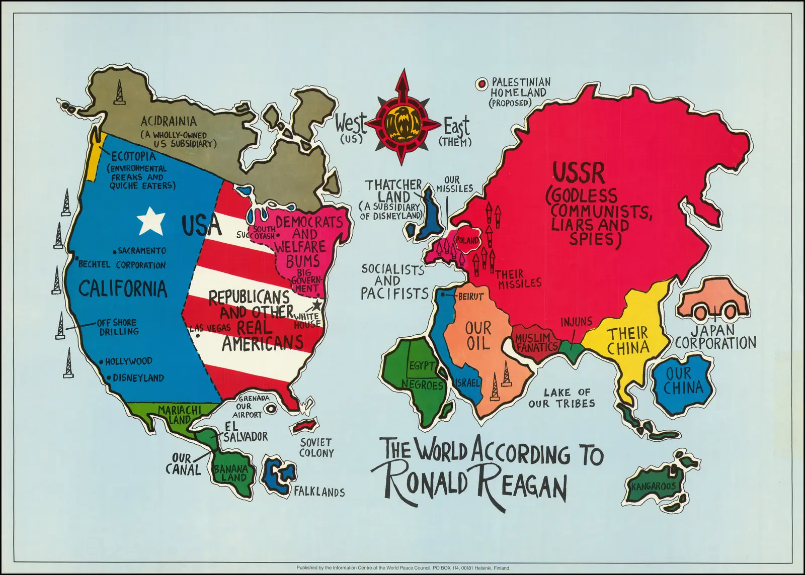
  • The World Map According to Ronald Reagan
     
  • In the geopolitical landscape of the 1980s, Ronald Reagan, the 40th President of the United States, left an indelible mark on the world map through his distinctive foreign policy approach. Reagan's vision was shaped by a commitment to staunch anti-communism and a fervent belief in American exceptionalism. His administration sought to redraw the global contours, challenging the influence of the Soviet Union. Through policies such as the Strategic Defense Initiative and diplomatic endeavors like the Reykjavik Summit, Reagan aimed to redefine the power dynamics that shaped the world.
     
  • His strategic alliances and emphasis on democratic values significantly influenced the geopolitical landscape, leaving a lasting legacy that continues to impact international relations today. The world map, as perceived through the lens of Ronald Reagan, reflects a period of dynamic shifts and ideological realignment.


Exploring Earth's Depths: Geology-Chart Vintage Poster Reveals Geological Marvels with Earth’s Core, Surface Model, and Striking Volcano Illustration

  • Geology Chart - Unveiling Earth's Geological Wonders
     
  • "Geology Chart" presents a captivating journey through time with a vintage educational poster that unveils the intricate model of the Earth's core and surface. This beautifully illustrated chart not only delves into the geological layers that compose our planet but also highlights the...


    View More

Discovering Old Antique Map of London

  • Discovering London's History: Vintage Map of London Reveals the Past
     
  • Embark on a captivating journey through time with our Vintage Map of London, a unique glimpse into the city's rich history. This meticulously preserved map invites you to explore the bygone streets and landmarks that have shaped London over the...


    View More

1827 Map of Asia and Australia - Featuring Australia (New Holland) and East India Islands From the 19th Century

  • 1827 Map of Asia and Australia - Featuring Australia (New Holland)  from the 19th Century.


  • The Finley Map of Asia and Australia from 1827 is a remarkable cartographic representation that encapsulates the geographical knowledge of the time. In keeping with the conventions of 19th-century maps, this intricate depiction encompasses Australia, then referred...


    View More

A Chart Map of The Easternmost East India And China

  • Navigating the East: A Chart Map of the Easternmost Part of East India and China
     
  • Embark on a historical voyage with our extraordinary Chart Map of the Easternmost East India and China, a navigational gem that unveils the maritime intricacies of the 18th century. Crafted with meticulous detail and accuracy,...


    View More

Antique Map of Asia: Exploring Ancient Cartography with Insights into Africa, Europe, and Polynesia

  • Old Map of Asia: A Pictorial Journey Across Continents


  • This venerable map of Asia, a true relic of the past, unfurls a captivating narrative that transcends the boundaries of the Asian continent. Crafted with precision and artistry, this antique map not only delineates the geographical features of Asia but also extends...


    View More

Bartholomews General Map of Asia.2, 1940

  • Bartholomews general map of Asia.2 - 1940
     
  • Bartholomew's General Map of Asia (1940) is a historical cartographic marvel that provides a comprehensive snapshot of the Asian continent during a pivotal period. Crafted against the backdrop of World War II, the map reflects the geopolitical intricacies and uncertainties of the time....


    View More
WhatsApp